Angelswing unveils a drone-based digital twin platform for urban safety automation at the 2025 World Smart City Expo.
Angelswing (CEO Won Nyoung Park) announced its participation in the 2025 World Smart City Expo, to be held from July 15 to 17 at BEXCO in Busan, where it will present its vision for safer and more efficient urban management through drone-based digital twin solutions.
With a mission to solve on-site disaster response challenges through technology, Angelswing has focused on using drone data to simplify complex public safety and disaster management tasks. The company aims to overcome the limitations of traditional manpower-based systems and contribute to solving social and industrial problems through cutting-edge technology.
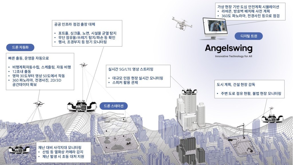
At the expo, Angelswing will showcase its all-in-one drone platform designed to enhance public safety and infrastructure inspections.
The core features include full drone operation automation, on-site virtualization, and a real-time 3D digital twin platform that enables routine and ad hoc public infrastructure monitoring in the easiest and fastest way.
Drones deployed at key stations operate autonomously without the need for a pilot. Collected data syncs in real-time with the digital twin environment to detect environmental changes and assess hazards.
On a virtual PC-based site, users can simulate safety plans by placing equipment across event venues and roadways, then use drones to monitor execution and prevent accidents.
The platform also supports 2D orthophotos, 3D modeling, and BIM integration for geospatial analysis.
Drone automation enables easy safety management across forests, construction sites, and event venues | Image provided by Angelswing
Public safety applications:
- Disaster prevention and early response: Drones detect wildfire risks, sinkholes, potholes, and flooding. Integrated with aerial CCTV monitoring, drones help fire and police departments respond rapidly, reducing further damage. Weatherproof drones equipped with thermal cameras operate in extreme temperatures and stream high-resolution video with 112x zoom for real-time situational awareness.
- Automated routine inspections: Drone stations automate operations for unmanned field checks of infrastructure, waterways, and illegal signage. Automated flight planning, route setting, and scheduling ensure regular image capture. The system detects cracks in aging buildings and bridges, monitors trash and illegal advertisements, and uses AI customized to municipal needs to deliver alerts and reduce inefficiencies in manual site visits.
- Real-time 3D digital twin platform: Automatically creates 2D/3D models from drone imagery, supports time-lapse and timeline management, and verifies project progress and design deviations from CAD or BIM in urban developments.
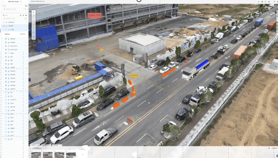
- Safety management module: Simulates safety plans with 3D icons and equipment range visualizations. SmartCapture allows one-click drone capture for collaboration and site safety planning.
- Interdepartmental collaboration and data management: Projects are organized by folder per agency. Access can be controlled per user account, enabling seamless cooperation between government departments. Drone imagery supplements blind spots of fixed ground CCTV, serving as legal evidence in disputes or land compensation.
Drone and digital twin-based data solutions for disaster response | Image provided by Angelswing
Deploying Angelswing’s solutions minimizes blind spots in public safety checks and streamlines communication across departments. Automated drone operations replace routine on-site visits, reducing pilot labor, hardware, and travel costs. The system can cut operating costs by up to 85% for sites spanning 40,000 to 500,000 square meters.
Rapid disaster response mitigates wildfire and road damage, reducing long-term recovery costs and improving budget efficiency. AI-based early detection of hazards, such as potholes and illegal signage, enables proactive governance, builds public trust in safety systems, and alleviates residents’ concerns.
Angelswing leverages Korean server-based cloud data management and API structures that are compatible with existing urban control centers and smart city platforms. The platform supports high-resolution LTE/5G streaming, 360-degree camera views, and time-lapse capabilities. AI modules that detect abnormalities are being tailored for municipalities to further enhance field optimization.
“As a drone data platform company with a mission to solve disaster response challenges through technology, we aim to redefine public safety and urban management paradigms with drone data at this year’s Smart City Expo,” said CEO Park. “We will contribute to building smarter, safer cities with advanced technologies.”
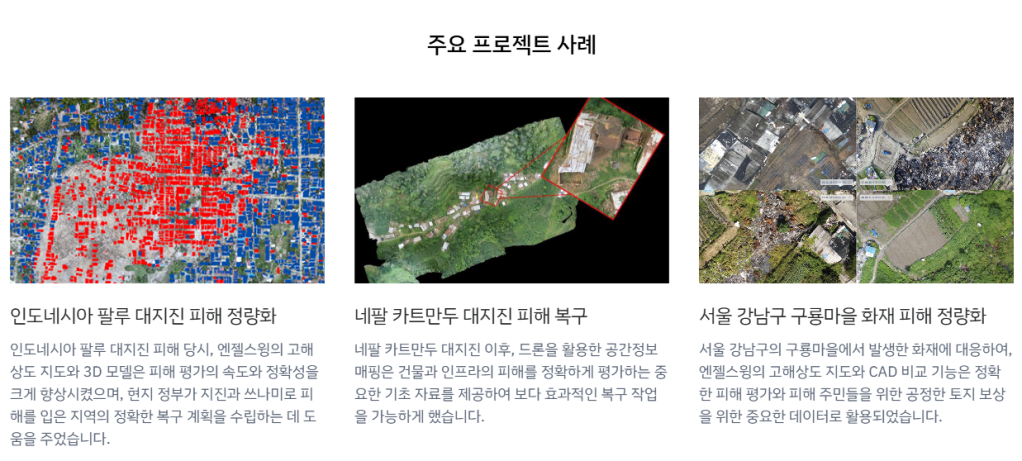
Park was named to Forbes’ 30 Under 30 Asia list in 2019. Angelswing provided spatial data for recovery from the Palu earthquake in Indonesia and the Kathmandu earthquake in Nepal. During the Guryong Village fire in Seoul’s Gangnam District, its high-resolution mapping and CAD comparison tools supported fair land compensation.
The platform has been adopted at over 500 construction sites in countries including Saudi Arabia, Singapore, Thailand, and Korea.
Visitors can experience Angelswing’s smart city solution firsthand at booth W F-02 at the 2025 World Smart City Expo. Construction professionals can receive tailored consultations during their visit.
Safety simulation and interdepartmental collaboration using virtual site visualization | Image provided by Angelswing
Angelswing is an advanced drone data platform company expanding its presence in the global construction sector with a mission to solve social and industrial challenges through technology. From winning two Grand Tech Awards in Korea’s Smart Construction Challenge to being the first Korean firm selected two years in a row for Geoawesomeness’ Top 100 Global Geospatial Companies, Angelswing has earned credibility with its top-tier digital twin solutions. Beyond construction, it is extending its virtual collaboration platform into broader city safety and infrastructure monitoring.

Leave a comment